A weak Canadian cold front will move across the area within the next hour or so. Winds at GXY have backed already. The models seems to be in disagreements on high temp and precip as the NAM and GFS have the the leeside low forming in different location. Depending on your model of choice/trust, it could be either a soaker or a lighter rain event for the Denver metro area.
This past week, It seems like the GFS00/12Z runs have out performed the GFS06/18Z and NAM models. I am hesitant to give the edge to any models right now. On a bright note, most of the precip if it falls will be in the form of liquid.
~ Ng
19 October 2009
12 October 2009
Home Field Advantange Does Not Equate into a Win...Just Look at the Rockies.
Our new mission for the next two weeks is to forecast for Denver, CO. If you choose to accept your mission here is the 411 WRT Climo on the DEN site.
Identifier KDEN
Elevation 1656 m
Latitude 39.84°N
Longitude -104.65°W
Normal High 68-63°F
Normal Low 37-33°F
Normal Wind Speed 8 knots
Normal Precipitation 0.03"
WX Discussion:
Unsettling weather trend is installed for this week in Denver. A Denver Cyclone is forecast to develop in the middle of the week out to our southeast. This will increase our chances for cloudiness and precip for the next few days. It depends on where eventually the cyclone will set up, precip amount can be heavy for some places but mainly to our east. Temperature should be above freezing therefore, snow or freezing rain will not be an issue. Temperature will be close to normal. Overall, I don't think precip will affect KDEN as much as the NWS has it their discussion.
This weekend temperatures will bounce back to normal with a flat ridge building into the region. Next week, we could see another shot of cold temperatures as a Canadian cold front is forecast to pass through NECO.
~Doc Ng
05 October 2009
Week Two CHS WX Dicussion
This week forecasts for KCHS should be more challenging as precipitation will play a role in our predictions. For the start of our day 5 forecast, lingering light precipitation will reside over the CWA. Temperatures will be unseasonable for Tuesday into Wednesday period. A shortwave will move north of the Carolinas by Wednesday night. This will usher in a chance of showery precipitation for Wednesday and seasonable temperatures and sunny skies by Thursday. On Friday, temperatures will be closer to normal and depending on how fast the next disturbance moves across the country, precipitation could be a factor towards the end of the day 8 forecast period.
Possible WX discussion revision during the midweek if warranted.
~ Doc Ng
Possible WX discussion revision during the midweek if warranted.
~ Doc Ng
30 September 2009
Charleston Lows
From the looks of it tonight that high pressure is building into the Charleston area creating the warm air inversion aloft. If this holds true this should create a blocking of the upper level winds so that warm layer wont be able to mix out, this added to the clear skies over night will contribute to the radiational cooling overnight. Therefore, I believe the models are slightly high on the over night temperatures considering nearly no on or off shore winds at the surface contributing to radiational cooling and the subsidence of the high into the region. Then again I could be way off!
Suaave~
Suaave~
28 September 2009
Let's do the Charleston!
We will be forecasting for Charleston for the next two weeks. Here are some useful information about the site
Identifier KCHS
Normal High 82-79°F
Normal Low 62-58°F
Latitude 32.89°N
Longitude -80.04°W
Normal Wind 7 knots
Elevation 15 m
Normal Precipitation 0.11-0.16"
Discussion:
A robust cold front with sweep across the SE US today. This front lacks the moisture punch to create any significant precip. Temperatures and winds will be the main concerns for this FROPA. Charleston CWA will be situated on the southern edge of the large upper-level trough so I do not foresee any significant change in the weather for the next 48 hrs. Temperatures and winds will be seasonal and precip chances are slim to none and slim just left town. Winds will be offshore for a good part of the week. Our next significant weather event will come this weekend as a disturbance moves across the Carolinas.
On a forecast side note, my experience with forecasting coastal locations W.R.T. winds has been quite challenging. My rule of thumb is to bump the forecast wind speed by at least a few knots since we are forecasting for max 2-min wind over a 24 hour period and not a hourly observation.
~Ng
09 February 2009
New York, NY
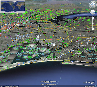
KJFK's observations are taken at John F Kennedy International Airport as shown in the image below.
Since this is a coastal location, you may find sea temperatures to be useful.
Central Atlantic temperatures can be found here: http://www.nodc.noaa.gov/dsdt/cwtg/catl.html
Temperatures further north can be found here: http://www.nodc.noaa.gov/dsdt/cwtg/natl.html

Since this is a coastal location, you may find sea temperatures to be useful.
Central Atlantic temperatures can be found here: http://www.nodc.noaa.gov/dsdt/cwtg/catl.html
Temperatures further north can be found here: http://www.nodc.noaa.gov/dsdt/cwtg/natl.html
10 November 2008
Some Quillayute-y Information
The town of Quillayute is actually really small. The ASOS is at the airport which basically serves the towns of Forks (to the east) and La Push (to the west, on the Coast). The elevation is 192ft and is in hilly, but not mountainous terrain, close to the coast.
Latitude: 47.93750; Longitude: -124.55500
Here is a link to the sea surface temperature at La Push:
(EDIT: The last link I posted was for historical data. This site has buoy data under "current weather" Sorry for the confusion)
http://www.swellinfo.com/surf-forecast/la-push-washington.html
That might be useful in your forecast, especially when you suspect the wind to be off the water.
Click the image below to get a general overview of the area:

Subscribe to:
Posts (Atom)